


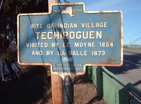
Site of Indian village Techiroguen visited by LeMoyne 1654 and by LaSalle 1673
| Problematic Issues | – The marker leaves out the importance of this site in indigenous economics and trade. – The words suggest that the first visits by Europeans (French Jesuit priest, Simon Le Moyne and French explorer, Robert de La Salle) in the mid- seventeenth century visits are what make the site important. |
| Location | Located in Brewerton, NY, on U.S. 11 and Bennett Street, at the south end of the Brewerton Bridge, near the place where the Oneida River flows out of Oneida Lake |
| Significance | Techiroguen was an Onondaga fishing village. The village at the outlet of Oneida Lake was on a well-traveled north / south route between the Onondaga villages to the south and the mouth of the Salmon River on Lake Ontario. This route was actively used for hunting, fishing, and trade (1). The location was also at the crossroads of the major east west route used by Haudenosaunee. Travelers from the Mohawk River could portage overland from an area near today’s city of Rome, NY into the Oneida Lake water shed and then travel by lake and river to Lake Oswego. During the 18th century, the French, English, and colonists saw this crossroads as strategic and sought to wrest control of this route – even though it was Haudenosaunee territory. During the French and Indian Wars, British and French troops crisscrossed this area. In 1759, the British built a fort at this site to defend colonies against the French. In 1779 Colonel Van Schanck and his troops encamped near here on their way to burn Onondaga villages. |
| Indigenous Names for the Site | The village was called Techiroguen, while the locality was known as Oh-saha-u- ny-tak se-ugh-kah (“where the waters run out of Oneida Lake”)(3). |
| Circumstances of Marker Placement | A local Brewerton historian, J.E. Milton, paid for this marker and 17 others (4). The marker was erected in 1932 as part of New York State’s Education Department commemoration of the Sequicentennial of the American Revolution. Over 2,800 of the small, cast iron site markers were erected statewide during the duration of this program (1926-1939)”(5). |
| Sources | (1)W.W. Clayton, “History of Cicero, NY”, History of Onondaga County, New York, D. Mason & Co., Syracuse NY, 1878. [http://history.rays-place.com/ny/onon- cicero-ny.htm] (2,3) H. Bruce, Onondaga’s Centennial. Boston History Co., 1896, Vol. I, pp. 807- 824. [http://www.rootsweb.ancestry.com/~nyononda/cicero/earlyset.htm] (4) “Markers put at Historic Spots Along Highways”, Oswego Palladium Times, Saturday, June 30,1934, p.5. (5)New York State Museum, “Outreach: State Historic Markers”, [http://www.nysm.nysed.gov/services/marker/srvmarker.html]. |